This blog covers trips from the book and other favorites.

2/20/12

Paddling Skagit River Delta - La Connor -Trip #26

Downtown La Connor
The Skagit River Delta chapter is quite extensive and includes Goat and Ika Islands, La Connor, and several river channels to the south.  Here's an image of the Rainbow Bridge in La Connor.  There's a new Cascadia Marine Trail campsite just below the bridge on the right (or east) side in Pioneer Park.  Also below the bridge is the only easy water access via a boat ramp in La Connor. For more info on the campsite check out www.wwta.org.

La Connor is a great place to grab a bite, a beer, and/or stock up for a trip while in town.

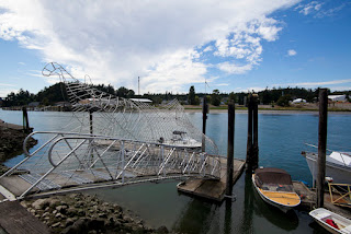
The image below of the wire fish sculpture is in the town of La Connor.  We couldn't find any info on whether it's ok to launch there.  The current rips through there on big exchanges and it's most often used by commercial fishermen.


Rainbow Bridge


Learn more about my book Kayaking Puget Sound and the San Juans, 60 Trips. I also offer SUP and Kayak lessons available throughout the year at Salmon Bay Paddle. Questions about paddling on the Salish Sea, give me a holler anytime at salmonbaypaddle@gmail.com or 206-465-7167

Support the Washington Water Trails Association and the Cascadia Marine Trail. The wwta works to create and protect access for paddlers on Puget Sound as well as provide an extensive network of over 60 paddle-in camping sites - www.wwta.org

2/17/12

Paddling Deception Pass State Park - Trip #28

Only 1.5 hours from Seattle, Deception Pass State Park is one of my favorite destinations.  It's known for it's swift tidal current and rapids which squeeze through a narrow a canyon with an large rock island in the middle.  Currents can run up to 8 knots and changes directions a few times a day.  River like features such as whirlpools, eddylines, standing waves, and boils draw experienced paddlers, clubs, and kayak schools to the pass to learn and enjoy the water.

DP as we call it, also has varied terrain which can appeal to paddlers of all skill levels.  Not far from the fast curent areas are protected coves and bays, pocket beaches, caves, extensive kelp beds, rock formations, and sandy beaches. One can paddle in the park without ever sensing any current or difficult paddlling.  I love to take my SUP there and when lucky surf up to 5' standing waves in Canoe Pass on the ebb at lower tides. The waves build when strong NW swell coming in from the Strait of Juan de Fuca collides with the ebb current in the pass.

Most common put-ins are Bowman Bay and Cornet Bay.  Both are protected launches each with their own features.  Those wanting to travel through the pass or play in the rapids use a Current Table to determine the best time to travel, which launch to use, etc.  For example, if the current is flooding (coming in) but will taper off by noon, you'll launch at Bowman Bay, take the flood through the pass and when the current tapers off and begins to ebb (going out) you'd take the current back out towards Bowman Bay.

Terms to know:
Ebb: outgoing current
Flood: incoming current
Slack: period of little or no current in between each cycle. Lasts 5-30 minutes.
Current Tables:  Find online or in print in most tide table books. Sample Here.


Tip: If launching from Bowman Bay, portage over the sandy isthmus on the south side of the bay to more easily access the current below Canoe Pass.

Here's a few images from less common perspectives in the pass.


Learn more
 about my book Kayaking Puget Sound and the San Juans, 60 Trips. I also offer SUP and Kayak lessons available throughout the year at Salmon Bay Paddle. Questions about paddling on the Salish Sea, give me a holler anytime at salmonbaypaddle@gmail.com or 206-465-7167

Support the Washington Water Trails Association and the Cascadia Marine Trail. The wwta works to create and protect access for paddlers on Puget Sound as well as provide an extensive network of over 60 paddle-in camping sites - www.wwta.org


2/16/12

Paddling Hood Canal - Quilcene & Dabob Bay - Trip #23

Located within an hour of Seattle, Hood Canal is known for its' oysters, quiet beaches, epic views of the Olympic Mountains, and tiny towns such as Lilliwaup, Brinnon, and Potlatch.  Quilcene on the northwest end is tucked inside two bays - Dabob and Quilcene Bays.  Most often, the water is calm.  Mudflats empty at low tides requiring the paddler to plan their route prior to departure.

From Quilcene, launch from the Herb Beck Marina south of town, or from the Pt Whitney Shellfish Labs beach. The Pt Whitney beach is strewn with oysters. I once saw a guy trying to get in his newly built wood strip kayak in a few feet of water to avoid scratching the hull.  Another method is to bring along those foam pool noodles to launch on if this is an issue for you.  I'd recommend booties or shoes while walking on the oyster covered beach.


Beach Launch from the Herb Beck Marina.


Learn more about my book Kayaking Puget Sound and the San Juans, 60 Trips. I also offer SUP and Kayak lessons available throughout the year at Salmon Bay Paddle. Questions about paddling on the Salish Sea, give me a holler anytime at salmonbaypaddle@gmail.com or 206-465-7167

Support the Washington Water Trails Association and the Cascadia Marine Trail. The wwta works to create and protect access for paddlers on Puget Sound as well as provide an extensive network of over 60 paddle-in camping sites - www.wwta.org


2/13/12

Paddling the Low Tides & Mudflats of Puget Sound

In a 2/12 posting on my paddling blog Stoke Magazine titled "9 Tips for Paddling Safely wth Tides," I offered tips on how to avoid getting stuck in mudflats on low tides.  Below is a list of areas in and around Puget Sound which are worth paying attention to if you're planning on paddling there.

General rule of thumb if planning of paddling in these areas - find out the minimum tide level to safely paddle there and launch on a rising tide.

South Sound -
There are quite a few inlets, bays, and coves here which completely dry out during lower tides. This is only a short list..
- Nisqually Reach / Delta, Trip #4.
- Woodward Bay (inside Henderson Inlet), Trip #3.
- Eld Inlet, Trip #2.
- Kopachuck State Park & Cutts Island, Trip #7.
- Gig Harbor, Trip #9

Mid Sound -
- Eagle Harbor / Bainbridge, Trip #13 & 14.
- Duwamish Waterway, Trip #16.
- Everett Harbor, Trip #21.
- Central Hood Canal, Trip 23 (mostly river mouths - Hamma Hamma, Dosewallips, etc).

Woodward Bay, South Sound.
North Sound - 
- Skagit River Delta, Trip #26.
- Deception Pass State Park, Trip #28 (Cornet Bay, Bowman Bay).
- Chuckanut Bay, Trip #31 (Larabee St Park south.)
- Padilla Bay.
- Warm Beach (between Camano Island and the mainland).
- Lummi Island north to Sandy Point and south near Eliza Island.

Olympic Peninsula - 
- Indian Island, Trip #34 (southern section).
- Discovery Bay, (south end).
Nisqually Reach, South Sound.
- Dungeness Spit, Trip #38.
- Sequim Bay, Trip 37, (by casino).

San Juan Islands -
- Lopez Island, Fishermen's Bay, Trip 44.
- Orcas Island, (Eastsound area).

Gulf Islands - 
- Sooke Harbor, Trip #54, (inner shorelines).
- Saltspring Island, Ganges Harbor.
- Pender Island, Trip 60 (various coves and inlets).

Other:
- Willapa Bay and eastern and northern Long Beach Peninsula.
- Columbia River from mouth upriver approx 10 miles.
- Grays Harbor.
- mouth of the Physt River inside of Pillar Point on the Strait of Juan de Fuca.
- north of Bellingham near US/CA border.


Learn more
 about my book Kayaking Puget Sound and the San Juans, 60 Trips. I also offer SUP and Kayak lessons available throughout the year at Salmon Bay Paddle. Questions about paddling on the Salish Sea, give me a holler anytime at salmonbaypaddle@gmail.com or 206-465-7167

Support the Washington Water Trails Association and the Cascadia Marine Trail. The wwta works to create and protect access for paddlers on Puget Sound as well as provide an extensive network of over 60 paddle-in camping sites - www.wwta.org


2/11/12

Paddling Trip #9 / Gig Harbor to Olalla

Located on Colvos Passage and the Kitsap Peninsula, Olalla is halfway between Southworth and Gig Harbor. Once known for it's strawberry crop which ripened earlier than other regions on Puget Sound, the 'town' consists of one small convenience store (closed at time of writing).  We passed through here on July 4th 2011 while updating this book and were excited to see the locals sunning on the low tide beaches, fishing, boating, etc.  The little inlet which dries out at low tide is also the boat ramp.

Olalla is a little over 6 miles from Gig Harbor to the south, and the same for Southworth to the north.  The Current in Colvos Passage runs mostly north, so think of that when planning a trip here.


Learn more about my book Kayaking Puget Sound and the San Juans, 60 Trips. I also offer SUP and Kayak lessons available throughout the year at Salmon Bay Paddle. Questions about paddling on the Salish Sea, give me a holler anytime at salmonbaypaddle@gmail.com or 206-465-7167

Support the Washington Water Trails Association and the Cascadia Marine Trail. The wwta works to create and protect access for paddlers on Puget Sound as well as provide an extensive network of over 60 paddle-in camping sites - www.wwta.org


2/8/12

Find NOAA Nautical Charts Online

If you're seeking charts for trips, check out NOAA's online site for a quick peek and/or to download.

Check it out.. http://www.nauticalcharts.noaa.gov/mcd/OnLineViewer.html


Learn more
 about my book Kayaking Puget Sound and the San Juans, 60 Trips. I also offer SUP and Kayak lessons available throughout the year at Salmon Bay Paddle. Questions about paddling on the Salish Sea, give me a holler anytime at salmonbaypaddle@gmail.com or 206-465-7167

Support the Washington Water Trails Association and the Cascadia Marine Trail. The wwta works to create and protect access for paddlers on Puget Sound as well as provide an extensive network of over 60 paddle-in camping sites - www.wwta.org

Paddling Patos Island, San Juan Islands, WA - Trip #50

Located a little over 4 miles from the north tip of Orcas Island, Patos Island offers the boater or paddler relative solitude, epic views, a protected gunkhole, and curvy sandstone rock formations.  The paddle from Orcas to Patos can be easy if the wind and currents cooperate, or rather hardcore if not. Definitely a trip for experienced paddlers. We rated it 'Exposed' given the remoteness of the island and the potential difficulty to get there.

From Saturna Island in the BC Gulf Islands, the crossing is only 2.7 miles but that's through Haro Strait which can also be easy, or not due to fast moving current squeezing between the islands.

Despite the feeling of solitude from this image, in the height of summer on a weekend there were 8 or so boats moored in tiny Active Cove.  The tent on the point was huge, could probably hold up to 7 and behind it tons of camping and food supplies scattered on the grassy point out of view.

Satellite View of Patos, Here.


Learn more about my book Kayaking Puget Sound and the San Juans, 60 Trips. I also offer SUP and Kayak lessons available throughout the year at Salmon Bay Paddle. Questions about paddling on the Salish Sea, give me a holler anytime at salmonbaypaddle@gmail.com or 206-465-7167

Support the Washington Water Trails Association and the Cascadia Marine Trail. The wwta works to create and protect access for paddlers on Puget Sound as well as provide an extensive network of over 60 paddle-in camping sites - www.wwta.org


2/7/12

Paddling Obstruction Pass and Orcas Island - Trip #44

Obstruction Pass (and island) are located between Orcas Island and Blakely Island. Sometimes swift current flows on both sides of the island giving you an easy free ride or if you time the currents poorly, a long hard slog to your destination.

Obstruction Pass Recreational site, (a former State Park) is located on the southern tip of Orcas Island and has a Cascadia Marine Trail site. Obstruction Pass has several access points from Doe Bay to the north, a public boat ramp across from the island on Orcas, and to the south, Lopez Island.

The following are images of the Leiber Haven Resort on Orcas which is adjacent to the public boat ramp


Learn more about my book Kayaking Puget Sound and the San Juans, 60 Trips. I also offer SUP and Kayak lessons available throughout the year at Salmon Bay Paddle. Questions about paddling on the Salish Sea, give me a holler anytime at salmonbaypaddle@gmail.com or 206-465-7167

Support the Washington Water Trails Association and the Cascadia Marine Trail. The wwta works to create and protect access for paddlers on Puget Sound as well as provide an extensive network of over 60 paddle-in camping sites - www.wwta.org

Surf in the San Juans?

For years, I've heard for San Juan Island locals talk of catching surf off the islands' southern sections.  I've spoken to two longboarders and one surf kayaker who have confirmed this.  Last summer a prone paddler boarder friend said he caught a really long ride on a waist high wave in False Bay.  And it's not surprising given it's location near the eastern opening of the Strait of Juan de Fuca which also delivers surfable swells to the west side of Whidbey Island.  For those not familiar with NW surfing, the shorelines along both the Canadian and US side of the Strait have been popular surfing spots for years.  For locals, waves must be a relief as getting to traditional surfing areas in BC or WA from the island is quite the trek.  San Juan Island is Trip #52 in the book.

The image below is from the SW tip of San Juan Island in September.


Learn more about my book Kayaking Puget Sound and the San Juans, 60 Trips. I also offer SUP and Kayak lessons available throughout the year at Salmon Bay Paddle. Questions about paddling on the Salish Sea, give me a holler anytime at salmonbaypaddle@gmail.com or 206-465-7167

Support the Washington Water Trails Association and the Cascadia Marine Trail. The wwta works to create and protect access for paddlers on Puget Sound as well as provide an extensive network of over 60 paddle-in camping sites - www.wwta.org