My obsession for exploring harbor / coastal defense forts started during a music camp on Marrowstone Island near Port Townsend in the late 1970's. Friends and I would skip class to explore the World War 1 era emplacements of Fort Flagler, then a relatively unknown fort. We knew every nook and cranny of the extensive fort and found many additional bunkers, usually fire control stations or searchlight emplacements hidden in the woods around the park boundaries.
In recent years, my interest has been renewed out of curiosity about the many hidden bunkers along the Strait of Juan de Fuca built during WW2 to support the cannons at Fort Hayden, now Salt Creek Recreation Area. As a photographer, I'm also working on a series of images showing the less known bunkers which are mostly covered by thick foliage and off the beaten path. These are hidden in the forest and when found appear like something out of an Indiana Jones movie. I'm motivated by the search as well as the find, which feels like 19th and 20th century archaeology.
Some are on private land and a few are in DNR areas. The largest and most public emplacements on the Strait are at Camp Hayden (Salt Creek) where visitors can drive through Battery 131 which once employed two 16" cannons. These were fired once, but a turn of events in the Pacific War led the installments to become quickly outdated. Nearby, a battery of two 6" guns on Striped Peak can be easily accessed by a dirt road above the ranger station. Other fire control stations (slit bunkers) can be seen by the tent camping area and hidden in thick foliage on Striped Peak.
To support Battery 131, fire control stations were installed at Angeles Point, Agate Rock, Lyre, Majestic, Pillar Point and on Cape Flattery. Panama Mounts which are concrete circles were installed at Angeles Point and on a peninsula (private land) above the west side of the Elwha River which can be seen on Google Earth.
If you ask a local, many won't know of any additional emplacements beyond the public Salt Creek emplacements. A few friends have explored and found a few emplacements over the years thus motiving me to find those and others.
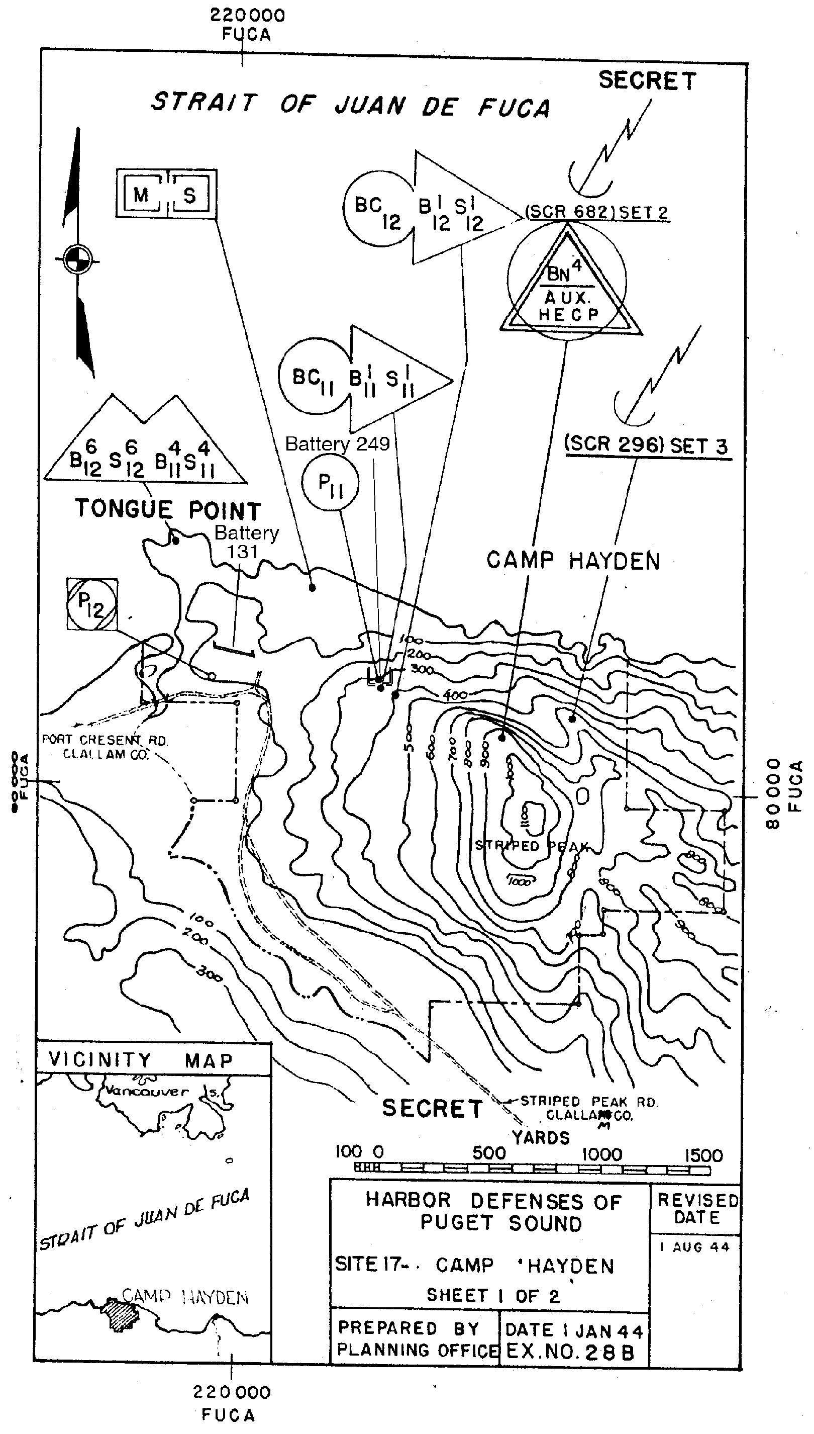
This link lists exact locations via Harbor Defense plans dating to the 1940's. But not all are as easily found as the maps show. Google Earth images show heavy forest over most of the sites and no sign of current or updated roads. A May 2017 search for the Agate Rock bunker was thwarted by dead end or heavily overgrown roads. It's on DNR land but bordered by private land on 3 sides. A Port Angeles local had been there and sent me a road map giving me a better idea of how to get there. Sounds like the best tool for search are a bicycle or motorcycle to more quickly access dirt roads and paths. We were on foot. In this video by RoadTrippers, motorcycles are used to search out bunkers in this area.

Learn more about my book Kayaking Puget Sound and the San Juans, 60 Trips. I also offer SUP and Kayak lessons available throughout the year at Salmon Bay Paddle. Questions about paddling on the Salish Sea, give me a holler anytime at salmonbaypaddle@gmail.com or 206-465-7167
In recent years, my interest has been renewed out of curiosity about the many hidden bunkers along the Strait of Juan de Fuca built during WW2 to support the cannons at Fort Hayden, now Salt Creek Recreation Area. As a photographer, I'm also working on a series of images showing the less known bunkers which are mostly covered by thick foliage and off the beaten path. These are hidden in the forest and when found appear like something out of an Indiana Jones movie. I'm motivated by the search as well as the find, which feels like 19th and 20th century archaeology.
Some are on private land and a few are in DNR areas. The largest and most public emplacements on the Strait are at Camp Hayden (Salt Creek) where visitors can drive through Battery 131 which once employed two 16" cannons. These were fired once, but a turn of events in the Pacific War led the installments to become quickly outdated. Nearby, a battery of two 6" guns on Striped Peak can be easily accessed by a dirt road above the ranger station. Other fire control stations (slit bunkers) can be seen by the tent camping area and hidden in thick foliage on Striped Peak.
To support Battery 131, fire control stations were installed at Angeles Point, Agate Rock, Lyre, Majestic, Pillar Point and on Cape Flattery. Panama Mounts which are concrete circles were installed at Angeles Point and on a peninsula (private land) above the west side of the Elwha River which can be seen on Google Earth.
If you ask a local, many won't know of any additional emplacements beyond the public Salt Creek emplacements. A few friends have explored and found a few emplacements over the years thus motiving me to find those and others.
This link lists exact locations via Harbor Defense plans dating to the 1940's. But not all are as easily found as the maps show. Google Earth images show heavy forest over most of the sites and no sign of current or updated roads. A May 2017 search for the Agate Rock bunker was thwarted by dead end or heavily overgrown roads. It's on DNR land but bordered by private land on 3 sides. A Port Angeles local had been there and sent me a road map giving me a better idea of how to get there. Sounds like the best tool for search are a bicycle or motorcycle to more quickly access dirt roads and paths. We were on foot. In this video by RoadTrippers, motorcycles are used to search out bunkers in this area.

Learn more about my book Kayaking Puget Sound and the San Juans, 60 Trips. I also offer SUP and Kayak lessons available throughout the year at Salmon Bay Paddle. Questions about paddling on the Salish Sea, give me a holler anytime at salmonbaypaddle@gmail.com or 206-465-7167
No comments:
Post a Comment